
University of Arizona scientists will be testing Mars exploration drones in Iceland. Christopher Hamilton, UA associate professor for the Lunar and Planetary Laboratory, is the principal investigator on this project. In order to learn more about the Mars exploration drones, the Daily Wildcat spoke with Hamilton about the project.
Daily Wildcat: What are you testing the Mars exploration drones for?
Christopher Hamilton: NASA has many different programs, and we tend to think about their programs including missions to send out satellites or to be able to explore other planets or even to be able to explore the Earth from orbit. But they also find a lot of other projects and one of the keys to being able to develop new technology is to be able to have ideas and to be able to test them.
There’s a program called PSTAR and that stands for the Planetary Science and Technology through Analog Research Program. This program uses different locations on Earth to analog sites that provide information about what other planetary surfaces might be like and allow us to be able to test different instruments, different mission architectures and different concepts. In working out some of those kinks we can develop a space-ready technology that would apply, in this instance, to Mars in the future.
DW: Is there a specific reason for it being done in Iceland?
CH: So, Mars has many different landscapes and one of the — to me — most interesting landscapes is the volcanic ones. Most of the environments that previous landers and rovers have explored have been in areas that represent relatively old Mars history. Early in the history of Mars, it was thought that there was a lot more water, there was a thicker atmosphere and there were hydrological processes that were more Earth-like. Therefore, a lot of the rovers like Spirit and Avenue are going to areas that were previous lakes, so water that had been an impact crater.
However, there are other areas that could potentially be good for understanding Mars’ geological history, but also the history from an astrological perspective, where life might have been able to exist. In Iceland, we see in volcanic terrains hydrothermal systems that provide opportunities for wildlife to be able to thrive.
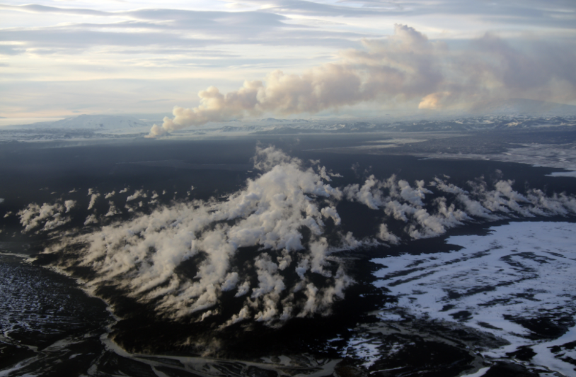
A few years ago in 2014 and 2015, the largest eruption in Iceland in 230 years took place in a part of the islands. We went there, studied the eruption while it was active and came back the summer after it finished. There were these hot springs that were emerging from around the lava flow and they were green, in an otherwise completely gray and barren landscape. Therefore, we came back the next year and sampled them and found all sorts of bacteria, algae and even some forming organisms that could potentially form in a similar environment on Mars.
With Raven, we’re going to be testing a combination between a rover and a drone to be able to access a volcanic terrain, which would be very difficult for a rover to explore on its own. All of those are extremely rough, they’re hard to walk on and they’re impossible to drive over if they’re relatively fresh. Meaning while you can fly over it with a drone and potentially even collect a sample with that drone, you could never explore that type of terrain on Mars using the traditional approach of a lander or a rover. You would need to land near a location like this and then fly out, examine it and potentially bring something back. This way could unlock a completely new era of Mars history, which is the geologically recent past.
DW: How does a drone work in space?
CH: Mars does have gravity; it has a surface area that’s about the same as all the continents on Earth. If you basically took away the surface area covered by the oceans, that would be close to the Martian surface. Its overall gravity is 3.7 meters per second squared and on Earth it’s 9.8 meters per second squared so it is about 38% of the Earth’s gravity. That’s not necessarily a problem, in fact having lower gravity is actually easier for drones to be able to fly, but Mars does have a much thinner atmosphere. Since it has a much thinner atmosphere it can be quite challenging to be able to fly.
The current Mars 2020 mission, which will end on Feb. 18, 2021, will demonstrate flight for the first time. It will accomplish this by using addition to the rover, a small drone called Ingenuity. That’s really going to open up the possibility by demonstrating that we can fly on Mars, to be able to develop larger and more capable systems in the future.
DW: What are your main goals with this project?
CH: In addition to being able to use these two systems together and demonstrate that technology is useful, the other key part is to be able to demonstrate the way in which we would use these two systems and so that’s referred to as science operations. One of the key issues in addition to testing the new drover is to be able to figure out how you can incorporate a drone into the workflow.
In the field, we won’t just have these robots; we will actually have people that will be participating in guiding a simulated Mars mission. We will have a number of students and a number of people that have never been to the area before. All they have are the images that we’ve collected using previous aircraft and drones that basically would simulate the remote sensing or the space-based imaging we have from Mars. They will design the mission, where they will land, the types of hazards they’d like to avoid and then begin to experiment with how they could use the drone to scout and the drone to collect the sample. They can request from our team that they would like to be able to obtain an image in a certain area and then we will send a drone and we will collect that data.
DW: What has your research looked like so far with Raven?
CH: Raven has these two key elements. The first element is the technology, which includes our drone and rover. Also, behind the scenes, a lot of computer software and particularly computer vision software to be able to make sense of the data.
One of the key issues that we have from a technological perspective isn’t just the vehicle, but it’s how you can generate data products and virtual environments from those data, then use computer vision systems to improve the localization and navigation capability, so under the hood, there’s a lot of software and programming. And then the science operations part really is geared towards what type of order we need to be able to use.
DW: How long will you be working on this project?
CH: Raven itself is a three-year project, so the next three years are going to be the core time for this project. Our first field deployments are going to be in 2022 and 2023.
Depending on what we find from that phase, we will be able to propose to do an additional study, but my hope is that additional work will include the design of a higher level of technical sophistication. There are these technology readiness levels that instruments need to be able to work through before they can actually fly. We’re doing the groundwork in the field and then my hope is that we will actually learn what exactly you would want to be able to build as an instrument.
The next phase of the project would then be building that technology to a point that we could actually send it to Mars. So, first the science, then this analog work and then really looking at that next level in terms of the engineering.
Follow Jillian Bartsch on Twitter