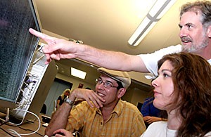
Scientists observed the UA HiRISE camera’s first high-resolution pictures of the surface of Mars on Friday afternoon and are preparing to receive data about weather conditions and polar ice caps on the red planet.
The High Resolution Imaging Science Experiment is a component of the Mars Reconnaissance Orbiter currently orbiting the red planet at an average altitude of 187.5 miles, said Sue Smrekar, deputy project scientist of the MRO.
The HiRISE camera is one of three cameras onboard the MRO, and its purpose is to capture high-resolution, close-up pictures of Mars’s surface, Smrekar said.
A contextual camera on board the MRO can zoom out and photograph a 30-kilometer region while the spectrometer can record light at different
wavelengths and determine the composition of the atmosphere, Smrekar said.
The MRO is also equipped with a wide-angle,
This mission will send back many times more data than all of the past missions combined.
– Sue Smrekar,
deputy project scientist
low-resolution camera that will track the dust storms to ensure that the cameras are not photographing during the storms, Smrekar said.
“”We will receive daily weather reports from Mars,”” Smrekar said.
What makes the MRO unique is its powerful 3-meter radar capable of sending and receiving data at rates comparable to the average cable internet connection, Smrekar said.
“”This mission will send back many times more data than all of the past missions combined,”” Smrekar said.
The orbiter successfully completed the aerobraking stage of the mission, where it dips into Mars’ atmosphere twice a day to circularize its orbit, said Kelly Kolb, a graduate student researching the gullies on Mars.
“”We had to be careful during this phase,”” Kolb said. “”If we got too close, it could have burned up.””
The MRO is now in a transitional phase as the instruments are deployed and tested for functionality, said Smrekar.
Besides the cameras, the MRO is equipped with a ground-piercing radar that emits low frequencies capable of penetrating one kilometer beneath the surface, said Smrekar.
The radar will primarily be used to study the layers of polar ice caps to determine if a deeper reservoir of ice lies beneath the surface or if condensation formed the ice caps, said Smrekar.
The orbiter will enter the primary science phase on Nov. 8 after the solar conjunction, when the sun is directly between the Earth and Mars, severely limiting communication between the orbiter and mission control, said Alfred McEwen, principle investigator of the HiRISE team.
“”(The scientists) are jumping around like little kids at Christmas,”” said Ben Pearson, an electrical engineering senior, after scientists received the photos Friday.
Raw data sent back from the camera via a powerful radar must first traverse an assembly line of software before the pictures can be compiled, Pearson said.
The data first comes in an Experimental Data Record format and then it is plugged into the Integrated Software for Imagers and Spectrometers, said Kris Becker, computer scientist with the U.S. Geological Survey.
ISIS translates the raw data into segments of the image, which are then stitched together to compose the image in its entirety, Becker said.
The scientifically accurate digital elevation models produced by ISIS convey the changes in elevation in full color, said Becker.
“”Imagine a two-dimensional drawing on a piece of paper, then folding that paper over a basketball,”” said Kolb.
The camera photographs the planet and factors such as the orbiter’s speed and direction must be taken into consideration before the three-dimensional image can be “”flattened”” into a two-dimensional picture, Kolb said.
One of the primary goals of the HiRISE camera will be to locate landing sites for future missions to Mars such as the Phoenix Mission’s Lander.


