
Struggling to keep up with a New Year’s resolution to stay active? Here are some Tucson trails with views that might help someone forget they are exercising.
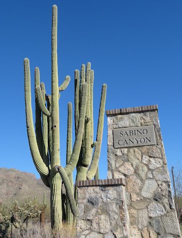
Starting off strong with Sabino Canyon, which contains 21 trails ranging from easy to difficult and reaching individual lengths up to 8.9 miles long. However, it is not uncommon for certain destinations to require taking multiple routes, such as Hutch’s Pool, making its mileage about a total of 15.6 miles long.
Sabino Canyon is a popular destination among Tucsonans looking to hike, bike and even camp. Keep in mind biking can only occur before 9 a.m. and after 5 p.m. every day except Wednesday and Saturday.
“You can literally hike the trails 24/7. The one thing that does close is the visitor’s center which is only open from 8 a.m. to [4:30 p.m.],” said Alfredo Vasquez, a forest technician who works in the visitor center at Sabino Canyon.
Here are a few of the trails located in this area:
Bear Canyon Trail
Bear Canyon Trail is around 8.9 miles long, out and back, but it leads to Seven Falls, where seven waterfalls fill a basin in the middle of the hike and create a natural swimming pool. The hike is labeled as ‘moderate to difficult’ because the trail requires crossing numerous creeks which, depending on the season, can contain very high and powerful waters.
Phoneline Trail & Blacketts Ridge Trail
Both of these trails are among some of the most frequented by experienced hikers looking to take advantage of the elevation gains Sabino Canyon has to offer.
Phoneline Trail reaches 3,680 feet and is 4 miles long. It is labeled as a ‘moderate’ trail. Blacketts Ridge Trail is 1.6 miles long, but it is considered ‘difficult’, reaching heights 4,400 feet in elevation.
When selecting a trail, it is important to make sure a persons expectations are in line with their body’s abilities.
“Our most popular trail is probably the Phoneline Trail. Sometimes people would rather do Blacketts Ridge because it’s the highest elevation in Sabino Canyon, but if they are unable to because they have a bad knee or have done it in the past, they go ahead and hike Phoneline,” Vasquez said.
The next set of trails are located in Mount Lemmon. These trails are perfect for those looking to escape Tucson’s typical scenery of saguaros and other cacti, as well as for those looking to do some elevation training.
Aspen Trail
Instead of prickly pear cacti, this 8.5 mile out and back trail will leave hikers surrounded by pine trees and of course, aspens! The trees allow for fall colors that are not always visible at lower elevations. It is a ‘moderate’ trail that peaks at around 9,100 feet.
Something to remain mindful of is that on trails such as Aspen Trail, the elevation can affect one’s usual performance level. Hiking with others, especially if someone is not used to the terrain or elevation can make a difference.
“It is always nice to be with somebody that knows what they are doing and that’s me talking from personal experience. I’ve been on some hikes in Washington state where no one knew where I was at […] once I started hiking the trails I was lost,” Vasquez said. “That experience scared me, it was a little discouraging but once I started being more cautious, aware and prepared it got better.”
Butterfly Trail
This trail comes highly recommended by Vazquez, who hiked the trail the summer of 2022 while performing research on the Bighorn Fire for the University of Arizona.
“One of the things I like about hiking [in] March through May is that it’s when a lot of the plants are producing flowers. You will see a lot more colors up there, since the plants are flowering you will see more birds and pollinators like butterflies and bees,” Vasquez said.
The Butterfly trail is approximately 11.4 miles, out and back, and reaches an elevation of around 8,500 feet. It is considered ‘moderate to difficult’ and takes over 3 hours to complete, so it is key to keep an eye on the time and the amount of daylight remaining.
“I would say some of the best times to hike the Butterfly Trail would be springtime and also maybe October through the end of November, before the snow hits,” Vasquez said.
Tumamoc Hill Trail
If someone is looking for an easy family friendly trail, look no further than Tumamoc Hill.
This trail is heavily foot trafficked from the moment it opens at 4 a.m. to its closing at 10 p.m. The hill has an elevation gain of around 700 feet.
Mary Whisler and Drew Maziasz, visiting Tucson from Cleveland, participated in a few hikes, one of them being Tumamoc Hill.
“It was tougher than I was expecting but I enjoyed it,” Whisler said.
“I enjoyed it a lot. We read that it was a place where a lot of people go hiking and walking every day and figured we should check it off the list. It was fun. It was nice,“ Maziasz said.
Whisler and Maziasz both recommend this short 3 mile, out and back, hike.
“Nice views from up top. If you’re looking for an easy well paved trail this is definitely one to do,” Maziasz said.
If someone is just getting started hiking and is unsure about how to begin, remember to go to visitor centers and ask which trail is best to attempt. Do not hesitate to ask questions!
“You can’t force someone to enjoy hiking but for people that are really wanting to start hiking and are serious about it, I would say just try to be as prepared as possible,” Vasquez said. “Try going with someone that has a little bit more experience in hiking than you and if they know the trails you want to hike, even better.”
Follow the Daily Wildcat on Instagram and Twitter (X)